


Local History Group
Following the success of recent beer festivals the FoMaS commitee have decided to fund a local history group
The aim of the group is to discuss share and document local knowledge through meetings held mainly on an afternoon leading to the production and placing of several History Boards throughout the villages of Staincross and Mapplewell.
Our meetings have already begun and with an average of 12 members research is ongoing.
Current Topics are listed below but will not be limited to those items.
We look forward to placing our findings on this website.
Note :- This Section is constantly being Updated.
Our Origins
Wapentakes
During Saxon times the land in Yorkshire was originally divided into three areas called Ridings, East, North and West. (A Riding derives from the Norse word 'thriding' meaning a third part). Yorkshire was subsequently further sub-divided into administrative areas called Wapentakes which is the Danelaw eqivalent of the Anglo-Saxon Hundred. Wapentake derives from the word meaning an assembly or meeting place, usually at a crossroad or near a river where one's presence or vote is recognised by a show of weapons.
The Staincross Wapentake
Staincross Wappentake was named after the village of Staincross. It is an ancient district in the county of the West Riding of Yorkshire which consisted of the parishes of Cawthorne, Darton, Felkirk, Hemsworth, High Hoyland, Penistone, Royston, Silkstone and included Barnsley and parts of Tankersley and Darfield. Of the nine Wapentakes in the West Riding Staincross Wapentake had the lowest population density which in 1867 was 27,089. Staincross derives its name from the old norse word stein-kross which literally means stone cross.
Blaeu Atlas Maior 1662-5 Volume 5

Shown below in Purple is the Staincross Wappentake in relation to the surrounding Counties and major Citys

The sheer size of the Wappentake can be better appreciated on the map below showing well known surrounding towns.

We are unsure as to why the Wappentake was named Staincross maybe the height of the area in relation to its surroundings may be the reason hopefully we stumble across the answer during our continued research.
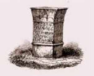
Staincross Wappentake - 1805 Beacon Lit
Research by Ann Gibson
Staincross Common to which Woodhouse Lane led is rumoured to have been a Wapentake Meeting Place from where men from 15 miles round were called together for a ritual touching of weapons. There is nothing to substantiate the exact meeting point but on ‘high ground’ around near a river or a crossroads. The beacon on Woolley Edge was accidentally lit in 1805 when Napoleons army invaded Boulogne. The Staincross volunteers assembled with ‘commendable promptness’ and having then gone on a fruitless march were greatly relieved when they discovered the French had not in fact landed at all. This decorated urn was presented to Walter Spencer Stanhope of Cannon Hall for successfully mustering 600 men to the Staincross Wapentake in 1805.

Early Village layout & Occupations
Panarama of the Village Derived from the 1807 Map at Bretton College
Note at the time Greenside was just a track and New Road did not exist. Colbecks Blacksmiths was as on an island at 4 Lane Ends

Occupation of One Head of each household in 1841

Enclosures
Research by Ann Gibson
It was custom to call the large house of any village or hamlet ‘The Hall’, as in Darton Hall, Staincross Hall, Bloomhouse Hall, Squirrel Hall and Dearne Hall. Sometimes the word ‘house’ was used for the chief building and they are sometimes referred as Darton House, Staincross House etc. The ancient Hall of the Denton family was at Broad Royd Head, Staincross. The Hall was demolished in 1939 when a clearance of derelict houses took place.

Many Halls were just farmhouses but this is not to be confused with Darton Hall or Gawber Hall which were in fact ancient buildings of the Tudor period. Gawber Hall was demolished in 1938 following severe subsidence from mine workings. In the 18th century it was practice for a man with the consent of the Lord of the Manor to enclose a piece of land and build a house on it. The Gee family of Staincross built a house and far buildings at Tipsy on Staincross Common land of the Royston parish. The land was cleared and it became a prosperous farm however following an enclosure act the farm was returned to the Lord of the Manor. In 1793 a Mrs Brown reported on the agricultural state of the West Riding she said, ‘Mr Beaumont’s tenants were unanimously of the opinion that all the Commons ought to be divided as they knew they only carried a few beggarly sheep and can now be improved into rich corn lands.’ The plots did eventually come to the market to be sold for building purposes and most of the building in the 18th century took place on Staincross Common, Carr Green, Mapplewell, Greenside and Barugh Green. Following the Enclosure Act of 1823 it was said:- ‘A sin it is in man or woman To steal the goose from off the Common But he doth sin without excuse Who steals the Common from the goose’ The people of Mapplewell speak of ‘Greenside’ not realising that a little more than a hundred years ago the Green was open land joining other open land which stretched for a mile in each direction. Excepting the enclosure of 15 acres in 1720 the common land known as Staincross/Darton Common is described as being:- From the NW of the parish, bordering on Notton townships a small row of nailshops at the top of ‘Greenside’ road and the house and outbuilding just below (Websters farm). The whole of the upper part of Staincross from the back of the common down to Broad Royd Head, Greenside to the bottom of Mapplewell and from Darton Lane Head to the east side of Staincross road. This was one big area of common land and was far the largest in the township. There was a narrow strip along the line of the water course from the bottom of Mapplewell to where the New Connexion chapel stood. (bottom of Spark Lane, Dearne Hall Rd). There was also a small island of enclosed ground on which stood Colbecks blacksmiths at the four lane ends. At the top of Mapplewell was a triangular piece of common land behind the Kings Head which went down to a point near Belle Vue House. There was also a strip along the roadside in front of Staincross Hall to the old hamlet of Staincross. Along the Barnsley road there was a strip of common land on each side from the shop at the point to Blacker Dyke. Along Wentworth Road to Hill End there was a continuous strip of common land now almost covered with cottages. The Commission set up at the time of the enclosure act also laid out roads, their width and direction. It also laid out bridleways and footpaths and allotments. Water courses were not to be diverted without consent of allotment holders.
North Gawber Colliery Disaster 12 September 1935 19 Lives Lost

Thankyou to Dave Alton who researched and wrote the following:-
Three o clock on Saturday, 14th September 1935. Kick off time at Oakwell, Barnsley v Burnley, Reds against the Clarets. But, the ground is silent. Every cap and hat has been removed as the bareheaded crowd immaculately observe a memorial silence. The all too recent calamity casts a pall over the game. Just two days earlier a calamity had befallen the community in and around Mapplewell when North Gawber Colliery exploded. The afternoon shift had only recently stepped from the cage that dropped them down the shaft. No doubt there had been talk about the impending match amidst the banter and jokes miners always shared. Just about 48 hours before kick-off, undercut coals were being shovelled onto a conveyor to be carried to the gate loader by No.3 South Level and emptied into tubs. At twenty to two Friend Clayton, a shot firer, set one off. An hour or so later he fired two more shots near middle gate of No.3 South Face. This time the pervasive darkness was disturbed by a sudden rush of wind and dust. James Crow, a young miner was working the loader when there came a flash and he was blown over and engulfed in smoke. Apparently, there was no noise, but a storm of dust. Close by, pony drivers Hubert Kelly, Claud Ackrord and collier Walter Riley had their clothes set alight. Sydney Hunter was initially blown off his feet, but got up and helped Kelly, Riley and Ackroyd towards the Middle Gate. Despite Kelly’s best efforts all three died of their injuries. Meanwhile, Crow and Clayton began dragging other injured comrades away from danger. William Boydell, having been blasted along the coalface, recovered enough to help Clayton with the injured. The final moments for so many must have been ones of confusion, fear and determination without any immediate prospect of rescue. One victim gave his last thought and action for another; “Farewell Fanny old pet” was later found chalked on a rock. Fanny may have been at her kitchen table when the rattles came, window panes in their frames and the lid unsettled on the tea pot. Ripples across the light tan of her tea in the cup. And then the hooter sounding. Out and dashing down the street between red brick houses standing shoulder to shoulder. Washing abandoned on backyard clothes lines with the tea left to go cold. Already praying, whether a church or chapel goer or not, she’d run to the pithead, along with so many alarmed wives, mothers, sisters. The first men joining the tumult: many from the last shift barely back home. Allotments and pigeon crees deserted without hesitation. The colliery like some dreadful magnet irresistibly drawing people to it. Four thousand family and friends gathering. In the pit yard so many miners had volunteered they could be organised into rescue shifts. The check office became the emergency dressing station. Ambulances so quickly on the scene were lined up to carry the injured away. From one rescue party came the report, “It’s like hell down there. Everybody is working to get the men, most of whom burned beyond recognition.” Stretchers were dragged in workings barely a yard high through a foul smelling miasma of dust so thick lamps were useless. By late evening the Barnsley Chronicle was reporting 15 deaths. By next morning, according to The Daily Mirror, the figure had become 16. Finally it was found that 19 colliers had died. On the 22nd October, Sir Henry Walker, H.M. Inspector of Mines, opened the official enquiry at Barnsley Town Hall., concluding 11 days later. Its findings were that a build-up of gas, firedamp, occurred due to poor, or even non-existent, ventilation. The firing of a shot detonated the gas in the confined space. No absolute proof had been found to indicate any specific individual responsibility. However, it was thought likely that, while firing a shot in such an unventilated area was a mistake by the shot-firer, the management should have been aware of the danger. A relief fund was subsequently established by Darton Urban District Council in conjunction with the mayor of Barnsley. There is an irony in Barnsley FCs’ opponents that Saturday following the disaster, as North Gawber Colliery was owned by Fountain and Burnley Co. Those killed were: Claud Ackroyd – Pony Driver Robert Brant – Collier Leo Bunting – Panman* Amos Dransfield – Borer Jacob Fallis – Panman Richard Hurrell – Machineman*** Albert Ibberson – Collier Hubert Kellt – Pony Driver Thomas Poyser – Collier Walter Riley - Collier Thomas Roberts – Panman* James Senior – Collier Albert Smith – Corporal** Thomas Smith – Borer Clifford C Walker – Machineman George Arthur Walley – Machineman Joseph S. Washington – Machineman John Willams – Borer George Wroe – Ripper**** *Panman – responsible for operating and maintaining underground conveyors. **Corporal – supervisor responsible for the underground haulage system. ***Machineman – responsible for coal cutting and undercutting machines. ****Ripper – widens and maintains underground roadways, sets supports, removes rock around the coalface.
FoMaS are proud to announce that we have purchased a glass check in memory of the above and can be seen in the Memorial Garden at The National Mining Museum, Caphouse Colliery


Pit Pony Racing
Researched and written by Ann Gibson
My uncle, Stanley (Stan) Turner was one of three generations of horse keepers mainly at Woolley Colliery. Stan’s father, Albert Turner drafted a book about his life with the pit ponies and at some point, I will endeavour to get it published as it gives a true insight into life down the pit for both man and beast. Initially the ponies were bought from a dealer named Siddle from Wakefield and later from a place called Schapiro’s, a dealer in Doncaster. The best ponies were from Russia, Lithuania, Ireland and then Wales. On one occasion thirty-two ponies were bought at Doncaster by two horse keepers who then walked them all the way from Doncaster to Woolley in eight rows of four. In his book Mr Turner states, ‘It was a sight to see.’ It was practice bringing the ponies out of the pit for so many weeks a year to graze in the fields and this in turn led to locals participating in the annual pony racing galas. The pony racing started in 1921. All the races are itemised in his book with names and the winners listed. The first pony race was held at North Gawber Colliery pit fields. There were three races, all bareback riders. In 1922 there was a dispute at North Gawber and all their ponies were brought to the fields at Woolley Colliery, there were 193 ponies in total. The dispute lasted 11 months and only two horse keepers were allowed to keep on working. It was not a strike but a lock out by the colliery owners. Only thirteen horses were kept and the rest were sold to other collieries. Once back at work 132 new ponies were bought. In 1926 pony racing was organised on a grand scale. There were three Gala days of racing and shows at the Queens Ground, Barnsley. 10,000 people paid admission and seventeen pits from South Yorkshire took part with sixty-eight ponies participating by 1927 there were 112 ponies taking part. In 1932 a Gala Day was held at Bretton Hall and pits from neighbouring counties attended. The prizes for the show were won by a colliery from Derbyshire. Mr Turner wrote: ‘I usually know a great many ponies from other collieries, the four that won were strangers to me and I have wondered many times if they were actually pit ponies, as they came to the Gala in luxury horse boxes!’ In 1935 Mr Turner’s son Stan became a horse keeper at the age of fourteen and when he married, he lived up Hope Street in Mapplewell. He continued to work with the ponies until the last one retired from the pit. Mr Turner mentions buying a Welsh cob on September 9th, 1942. The horse was black with a white star on his forehead. He states that this horse won more prizes than all the other ponies in the shows he was entered for. He won more than seventy 1st prizes and more cups than he could remember for best pit pony in show. Twice this pony went to the Royal Agricultural show as a representative for Yorkshire ponies. The pony’s name was ‘Captain,’ and he was quite famous at North Gawber Colliery. He was still living at the age of 21 in 1959 where he was living in a field near the colliery with other retired pit ponies. The last pony race was in 1947 as the Nationalised Coal Board issued instructions that the sport was cruel and detrimental to the ponies. The RSPCA recommended the practice was stopped as the races had become large events which involved lots of betting. The last pony to retire under the care of Stan was in 1970. I will finish with a story about one of the ponies called Tony. When he retired he was put to pasture in the neighbouring fields at Woolley with the rest of the ponies. However, he escaped and was found waiting by the crate at the pit shaft to go back down the pit. Eventually he was stabled near the pit top due to his escapades and he seemed to settle more.
Highwayman John Nevison
Researched and written by Ann Gibson

Along with Dick Turpin and Jack Sheppard, John Nevison was a famous highwayman who frequented the area. According to local history there is a stone in the grounds of Woolley Hall with the inscription, ‘Here Nevison killed Fletcher’. Nevison was regarded as a popular sort for robbing the rich to give to the poor, he earned his living by stealing from the growing number of road travellers. He was arrested many times and in 1674 he escaped from Wakefield gaol before charges could be brought. In 1676 he was arrested and charged with robbery and horse stealing and was sentenced to transportation to Tangiers. He subsequently deserted and returned to highway robbery. In 1681 he was arrested again but escaped as his accomplice masqueraded as a doctor and pronounced Nevison dead of the plague. His subsequent downfall ensued when he killed a Constable called Fletcher who was trying to arrest him. A tip off from the landlady led to his arrest at the Three Houses Inn Sandal. He was tried and hanged at York. He is buried at St Mary Church, York in an unmarked grave. In November 1788 three men stopped a stage wagon and stole goods from Wakefield to Barnsley. Somewhere near to Staincross where the driver left his horses at the Tollbar to run into the village to raise the alarm. The men were captured and committed to York Castle. On 27th December 1788 a coach was again robbed by two men whilst passing over Staincross common. Six weeks later the mail bags were found hidden behind an enclosure wall by two boys out rabbiting.

14th Century Offenders
Researched and written by Ann Gibson
(Extracts from the Court of Liberty of Staincross held Barnsley May 4th in the reign of Henry IV) William Fleming of Darton parish came to ground of Robert Rockley, knight of Woolley and felled and took away one oak tree – fined 12 pence. Thomas Jagger of Kexborough who hid money underground had said money stolen by John Silcocke the younger and afterwards came into the hands of Robert Rockley of Woolley. William Tottie the Constable of Woolley did not attend therefore fined. William Hinchliffe of Woolley and Robert Wright of Hemsworth are players of forbidden games. William Tottie of Woolley has also turned the course of water. William Hinchliffe made off from the Constable of Woolley and would not be arrested. It is noted that ‘Woolley people appear to have been desperate rogues especially Wiliam Hinchliffe.’ William Hinchliffe is to be punished as he has not repaired his hedges between Woolley and Notton. Richard Wheatley and Richard Crawshaw have obstructed the way from Woolley to Wakefield. The township of Notton have repaired their stocks – they are exonerated. Alice wife of William Highley of Notton and Simon Jackson are common scolds against the peace. Simon is a foul-mouthed rascal and Alice a common stealer and carrier away of cock’s hens and sheaves.

Roman Altar
Researched and written by Ann Gibson
It seems that the Romans did manage to visit our neighbourhood as a roman altar was discovered on Staincross Common in 1782.
It was inscribed;
DEO MAR
PRO SALVT
DD NN
IMP AVG
Meaning ‘To the God Mars, for the welfare of our Lord the Emperor Augustus.’
The altar is believed to have been in the possession of Mr Beaumont of Bretton Hall and an application was made to Mr Beaumont for further information without any success.
It’s current whereabouts are not known. Roman coins have been previously discovered on land off Staincross Common.
Research is currently ongoing into a possible site of a Roman Bath however recent discoveries suggest that the ‘Bath’ may well have been a Bathhouse built by the Shaw family of Staincross Hall in the 19th Century. The ‘Bath’ was destroyed when housing was built in the area.
An Example of a Roman Altar
History of the Local Iron industry (nail making) in the Mapplewell & Staincross area
Many Thanks to Duncan Biltcliffe who reseached and provided the following information :-
IRON Ore
Within eight miles of Staincross and Mapplewell the production and transformation journey of Iron Ore to Iron Nails. The raw material “iron stone” is generally known in this area as the “Tankersley Bed” and stretches from Emley in the north to Sheffield in the south. Mining of the ore in the Bretton area has been in existence since the 12th Century undertaken by the Cistercian monks, prior to the dissolution of the monasteries. In 1538 Monk Bretton Priory gave permission to the Wentworths of Bretton to produce iron. Visually the iron ore is a nodular shape stone with a sandstone hue and at Bretton it sits close to the surface in a 2.4 m thick bed. The iron ore or iron stone outcrops just below the surface in various places west of Mapplewell and Staincross. In the Emley area, It was mined using the bell pit method, hence close to the surface the remnants of these pits are still visible and can still be seen (OS Map) to the south and east of Emley.
SMelting the IRON Ore
The furnaces in the the area were:- 1 West Bretton Furnace ( Park ) 2 Barnby Furnace (Cawthorne) 3 Banks Furnace (Emley) The mined iron stone was carted to the local smelt or furnace and was reduced into iron by:- A. The older method of Bluming by mixing iron stone and charcoal, being placed into a pile and a case was built around it using clay or ganister; to vent the fumes a hole was left in the top as a flue and a hole in the base to accommodate a foot or hand bellows. After a while the iron ore would had liquidized and settled in the bottom, the blume would then be broken open exposing the solidified iron. B. The newer method was a much larger built for purpose furnace that could be used many times the furnace was constructed of stone or brick, the inner lining of the furnace was lined with ‘Ganister’ a gray clay like material obtained locally by extracting from the coal bearing strata, the furnace was loaded from above with iron ore and charcoal, this was later superseded by coke (a by product of coal). Limestone was introduced as a flux and this helped to refine the end product. To raise the furnace temperature a large bellows was required and was usually powered by water, the water race at Bretton is still intact and is connected to a run-off from the top of the dam head via the River Dearne. The nearest furnace to Mapplewell and Staincross is at Bretton Park, (now Yorkshire Sculpture Park). Remnants of the water race and furnace and slag/spoil heap are still visible, (100 meters from the Weston) this furnace never used coke and produced iron until 1806.
CHARCOAL BURNING
This decimation and clearance of the woodlands to facilitate a continual supply of charcoal, deforested much of England for a never ending supply of charcoal . The base product was coppiced timber. To harvest a tree was a 3 to 4 years cycle, beech, birch, and ash were the wood used, initially the tree trunk was cut near to ground level, a number of shoots would then start to shoot these were left for 3 to 4 years then harvested by again cutting back at near ground level and the cycle of coppicing started again. The coppiced wood would be placed and built into a manageable pyre, encased in a heat and smoke impermeable coating of ganister, soil or clay, anything to seal the pyre and keep out oxygen, a fire would be lit underneath and all the holes sealed up. After 14 plus hours the transformation into charcoal will have taken place. It takes about 2 tons of charcoal to make one ton of iron. The woods to the west of Litherop Rd High Hoyland was harvested and used for charcoal burning well into the 20th century.
the foundry and forge
It is quite possible that the iron from the Bretton Furnace may have been transferred a short distance to the Haigh Foundry about 200yds south of the Bretton Furnace, and then been further melted and poured into moulds to form cooking pots, farming tools etc . A further process was required to convert the carbon rich iron into wrought iron, The iron was stirred (puddle) in the furnace to release most of the carbon, its temperature was reduced partially to solidify it, removed from the furnace then hammered or rolled, the result was wrought iron, a fibrous grained material, easily forged under a low heat into all types of implements including various sized shapes (cannon) including rods for the nail industry. Blacksmiths were the main recipients of the wrought Iron.
Myth or fact
Many years ago, I saw an old reference (I have long since lost) relating to an iron chain manufactured at the Bretton Furnace that was used to block the entrance to the River Thames during the Spanish Armada of 1588, (myth or fact?) It’s a long way to London by road or sea. But-----From Wikipedia John Silveste r 1652/1722 Held the Lordship Birthwaite and Kexborough. He was a blacksmith at the Tower of London and is said to have constructed a chain that was to be drawn across the River Thames in case of an invasion by the Dutch fleet. In 1667 the Dutch Fleet did indeed sail up the Medway and destroyed the English Fleet (but John would have been just 15 at the time) Was there possibly a second chain manufactured at a later date? Some of these iron links still exist today on show in the Thames Medway London. D Biltcliffe 2015
Nailmaking
Many Thanks to Duncan Biltcliffe who reseached and provided the following information :-
In the 1850s family life was a hard one all the family members had to pull their own weight, both sexes and all ages were actively working a full day of possibly up to 14 hours, it was not unusual for children some as young as 6 to be working at the forge. Nailers were paid on a piecework rate the more you produced the more you earned. A good Nailer could produce up to 1800 a shift for the basic product. The end price would be reflected in its weight. An Extract from The Firm of Waring Bros Alfred Waring was a Mapplewell hand nail maker, a free man having his own smithy. He was a father of a large family and all when quite young had to learn to make nails, three of the sons George, Wilson and John eventually went to work for a nail maker called Dransfield who employed a number of men. George the eldest and John had a disagreement with Mr Dransfield over low pay and decided to set up on their own inviting Wilson who was Dransfield’s foreman and better paid earning seven pence an hour to join them. (Barnsley Archive B672.3)
Nailers of 1822 Nail Makers at Mapplewell Nail Manufacture at Staincross James Barton Joseph Shaw (Staincross Hall) John Cooper Thomas Walton William Monsieur Joseph Pecket Thomas Pickering

Nailers could be found at work any time of the day and at almost all hours. At the rear of the house is a typical nail-shop. It is a small building about 9 feet square and as many high. in the centre is a small blacksmiths hearth and grouped closely around it are four blocks or “stalls” at which were four persons – one man and three women hard at work making hob- nails. There are three generations of the same family grandfather and grandmother, daughter and granddaughter. The old people are bent and worn with age and toil, their daughter a woman of middle age, presents unmistakable evidence of a hard life (The English Illustrated 1889)

Female Nailmakers of Mapplewell
Manufacture of a Nail
Sticking the iron rods in the fire which is kept going by a pump of the bellows the rod point is heated to about cherry red, it is removed by hand from the fire and with a few sharp blows forms the point, the part formed nail is placed onto cold set (Like a cold chisel) and given a sharp blow to sever it at the desired length, when a batch has been made the nail is reheated at just the head end, then placed in a small steel ring and given a quick strike to form the nail head, to obtain a quality product a fast working speed is required

The correct term should be wrought iron nails not iron nails as iron is in fact a product of infusing or soaking the base molten material with too much carbon (from the charcoal)
The location of many of the Nailshops can be seen in the previous section on the 1807 Maps


Since the image of 1980s was taken the building has now disappeared, only part of the wall on the left-hand side of what was probably the living accommodation exists it still shows signs of wall paint plus the two bricked up windows.
During the Groups Research Duncan Biltcliffe came across the following :-

Extract from These Days & Those Days United Village Partnerships

An actual Painting of the Bethel Nailships located at the side of the Bethel Chapel painted by Arthur Branston can be seen below

The Above Picture courtesy of Ann Shaw
Bethel Chapel 1829
The first body of trustees consisted of. William Hall. James Broadbent. Job Dransfield. Joseph Peckett. James Hodgson. Joseph Ellam, John Birkinshaw. George Ledger. William Gee. Andrew Barton. George Shaw. John Cook. Barnsley William Hildred. Barnsley. Messr’s Peckett and Dransfield and were “nail masters” men who traded in the various kinds of handmade nails, an important industry in the village in those days, paying nail makers men women and even children on a piecework basis by cash, kind or token the latter being accepted in lieu of cash by local shopkeepers, and afterwards redeemed by the nail masters. Of the others Messes Birkinshaw, Broadhead, Hodgson, Shaw and Gee were actual “nail makers” who had support the comparatively large families that were then the rule and it is authoritatively stated it was the common custom for such men to leave the nailshop (workshop) have a hasty “wash and brush up” to attend the class meeting clad in working attire with well worn leather apron, have a “good time” there and return to the nailshop for the rest of the evening! Strange to say only one of the trustees, George Ledger was a miner.
By Kind Permission of Ken Brook (2026) and taken from his book.
"The Past and Way Ahead"
Nailmaker - Billy Monsieur & Old Bolton
By Ann Gibson
William Monsieur (Billy) was a master nail maker in the village. It was said that he often made 3 sixpences out of one shilling by cutting and shaping and he would often pass them off at the Wentworth Arms kept by Timothy Overend. Apparently, Billy saved enough money to build a row of cottages which may be located on New Road. It was a saying for many years that ‘all the slape sixpences came from Mapplewell.’ Billy was born at Woolley to John (stable groom) and Rebecca Monsieur. He died in 1858 and is buried at Darton Church. In 1821 there were six master nail makers in Staincross namely Thomas Pickering (Talbot Arms), James Barton, William Monsieur, Joseph Peckett, Joseph Shaw and Thomas Walton. By 1840 they had increased to nineteen. In 1840 in Mapplewell there lived a man nicknamed ‘Old Bolton’ such was his skill that he could make 1,000 nails a day each with perfect heads. Old Bolton walked twice from Staincross to Wakefield Bridge carrying four stone of coals. On his return the second time he danced the hornpipe outside the Wentworth Arms public house.

Picture of a Nailmaker from the Barnsley Chronicle Archives
Turnpike

Turnpike Trusts
Many Thanks to David Heald for his work researching and providing the following Information
The term Turnpike (or toll gates) referred to the military practice of placing a pike staff barrier across a road to block and control passage. Upon payment of a toll the pike would be ‘turned’ to allow rite of passage. The principle of making travellers pay a contribution towards the upkeep of roads they used began in the Middle Ages. In Medieval England the King would grant ‘pavage’ (a medieval toll for the maintenance and improvement of a road or street) to people or organisations and allow them to collect tolls. At the beginning of the seventeenth century, British roads were in a terrible state. Previous to this a law was passed in 1555 which instructed local people to maintain roads in their area but this was largely ignored. The first turnpike trust was authorised in 1663 by the justices of Hertfordshire, Huntingdonshire and Cambridgeshire who petitioned for an act allowing them to levy tolls on a short section of the Great North Road between London and York which would be put to keeping the road in a good state of repair. In 1706 the momentum of the turnpike system increased. From then a system of turnpike trusts spread and the rapid increase in industrial production between 1700 and 1750 resulted in the need for an improved road system. Acts were passed to allow bodies of gentlemen to set up turnpike trusts. This extended to almost all parts of England. The system after 1706 depended on local initiatives and people interested in certain parts of the road joined to form committees and became trustees. Once a local turnpike act was obtained the trust would accept competitive bids at auction and allocate the collection of tolls to the highest bidders. The creation of turnpike acts became prominent in the 18th and 19th centuries and by 1840 there were about 1000 turnpike trusts managing approx. 20,000 miles of roads but Parliament failed to make best use of the turnpike system. They allowed most trusts to be too small as they managed only ten to twenty miles of road and often, they could not pay their way. Many toll houses were built in the eighteenth and early nineteenth centuries as a result of the turnpike trusts. In 1840 there were approx. 5000 toll houses operating in England, standard design of toll houses in the 1820’s were small single storey cottages with a polygonal shape. Those built in the early nineteenth century had a bay front so that the pikeman had a clear view of the road, the turnpike barriers were positioned at the side. The coming of the railways intensified the financial difficulties of the turnpikes. Between 1865-95 the turnpike system trusts broke up and slipped back under parochial control. When the turnpikes closed many of the properties were sold off in the 1880’s or demolished but several hundred remain today. After taking 232 years to grow and flourish, the turnpikes decayed and came to an end. The Local Government Act of 1888 created County Councils and gave them authority for maintaining major roads. The abiding relic of the English toll roads is the number of houses with names like Turnpike Cottage
Staincross Turnpike
The Barnsley to Wakefield Turnpike Road, now the A61, was built in the 1700s as a toll road. The passing of the turnpike act for constructing the Leeds, Wakefield, Barnsley and Sheffield Turnpike Road in 1759 conferred a great boon upon Barnsley and the surrounding district. The first meeting of the trustees for the turnpike road was held at Wakefield and the road was divided into two sections -this was in the reign of George II of Great Britain (1727-1760) - the turnpike was set up from Sheffield to Wakefield. The toll houses designated on the road between Barnsley and Wakefield were at Sandal Bar (where a weighing machine was established and a bar installed across the north side of Sandal Three Houses Public House), Manygates Bar and Barnsley Old Mill. There is no mention of a turnpike or toll house for the Staincross area and perhaps the turnpike crossroad was named purely because the road was a turnpike road. On the 19th May 1875, The Select Committee on Turnpike Acts Continuance at the House of Commons considered the position of the Turnpike Trust and decided it should only continue to 1st November 1876. In that year on the 27th October the Wakefield to Sheffield Turnpike Trust expired. The toll gates and bars were removed and taken away with great rejoicing. They had in fact been disturnpiked.
Turnpike GARAGE
The images in this section have been kindly provided by Diane Heathcote (the daughter of Geoff Grundy) from a personal photo album
Written and Researched by Ian Gibson
Turnpike Garage is located on the A61 Barnsley to Wakefield Road near the Junction of Shaw Lane and Lee Lane and has been the main source of fuel for our vehicles for many years along with repairs and main dealer car sales showroom.

The following images show how the garage evolved through the years from its origins under JJ Storey then Geoff Grundy who initially worked for JJ Storey prior to taking full ownership of the Garage


Geoff Grundy
Read the full section for a surprise ending


In 1969 Geoffs passion for Rallying moved up to another level when he purchased a Works Mini Cooper previously driven by Timo Makinen in the Monte Carlo, 1000 Lakes and Flowers Rallies. This car was the British Motor Corporations No.1 Rally Car in 1968 Reg No. ORX 77F


Following the change of Dealership for BMC to SAAB Geoff bgan rallying Saabs not a common make of car in this country but Geoffs skills at Rallying once again led to success.


So back to the Mini Cooper ORX 77F.


So we have a happy ending and the new owner and Diane have each others contact details and im sure will share their stories.
17th Century-Law and Order
Researched and written by Ann Gibson
10th October 1671 Barnsley sessions. Matthew Prince, High Constable of Staincross Wapentake is to find out who kept bows, guns, greyhounds, setting dogs, ferrets, coney dogs, lurchers, hare nets, hare pipes, snares or any engines for destroying game. There were many poachers in the 17th century and there were many beggars and vagrants.

1624- Michael Wentworth at court for not filling up or covering old coal pits dug on the commons of Darton township – a great danger to passersby.

Woolley Hall bought in 1599 by Michael Wentworth and rebuilt in 1635.
Interesting Snippets
Researched and written by Ann Gibson
Visit of Preacher John Wesley

On 27th July 1761, John Wesley, a prominent methodist minister preached at Staincross at about 11am. It was Mapplewell’s feast Monday and according to tradition the place where it occurred was an area known as Carr Green, where he stood upon a huge flat sandstone (the covering of a draw well), where the footpath from Spark Lane used to join Carr Green Lane. The stone and footpath were over time covered by the colliery refuse heap. The preacher was then entertained by Elizabeth Shaw of Staincross Ridge, probably for a meal and short rest.
Land Dispute and Lady Savilles Funeral Procession

Camdens pen and ink drawing of an Elizabethan funeral procession
In 1603 there was a dispute over pasturage on Staincross Common. Mr Burdett of Birthwaite Hall laid claim to parts of the common which Sir Michael Wentworth had purchased from the Woodrove family of Woolley in 1599. There was no permanent settlement and the disputes arose again in1613 and 1625. In 1613 Wentworth annexed Staincross Moor and turned off the freeholders, he then moved his rabbit warren from near his home at Woolley to Staincross Moor. The rabbit warren according to old maps was relocated to land between Warren Lane and Windhill Lane. In the reign of Charles I, the Wentworth family of Woolley brought a petition to the Star Chamber against Lady Ann Hutton, widow of Thomas Hutton for a riotous entry into his warren on Staincross Moor and for killing of rabbits on it. Lady Hutton disputed Wentworth’s right to the common. She produced deeds and papers which told of a curious notice of a funeral procession of Lady Savile across the common to Thornhill church where she was to be buried. The papers stated that procession of the said corpse was carried from parish to parish from Sheffield to Thornhill. It states that the Vicar of Darton did take up with the procession unto a place over the waste in variance called ‘Wyndhill Gate’ (Near Windhill Farm) where they set her down to rest before completing the journey. Mr Wentworth subsequently lost his case.
Joseph Brammer - Marriage

Joseph Bramah, born in 1749, a great inventor from Barnsley married Mary daughter of Francis Lawton, a yeoman of Mapplewell.
Incidents/occurrences in Mapplewell and Staincross in chronological order
Researched and written by Ann Gibson
In 1745 there was a great storm in Yorkshire and damage was caused to fields and gardens by hailstones some were up to 5 inches in diameter.
1751 – There was a very infectious distemper amongst horned cattle in the Yorkshire area.
On 13th May 1751 Charles Watson Wentworth (Marquis of Rockingham), Wentworth came of age. A celebration of the event was held at Wentworth Woodhouse where great crowds assembled from villages around Barnsley, Rotherham and Sheffield to participate and witness the entertainment. There were 10,000 guests, 3,000 of which were entertained in the house itself. The entertainment consisted of 110 dishes of roast beef, 70 pies, 55 dishes of mutton, 70 dishes of veal, 40 dishes of chicken and 104 dishes of fish. The liquors drunk was 13 hogsheads of ale, 20 hogsheads of strong beer, 8 hogsheads of punch and 4 of wine. (A hogshead is a cask of beer equal to 54 gallons or 52.5 gallons of wine.)
The computation of time- 1752
The computation of time took place to the ‘New Style’ by order of Parliament. In this year we had as a nation got behind true time by as much as 11 days. Julius Caesar had fixed the calendar so that a year was in fact 365 days and 6 hours. The error had already been corrected by some civilised nations. In 1751 Lord Chesterfield drew public attention to the circumstances and he brought a Bill before Parliament which stated that the legal year should begin on 1st January instead of the 25th of March. To correct the calendar 11 days were to be omitted in September 1752. (6th January was often referred to as the old Christmas Day.) However common people thought that Parliament was going to shorten their lives by 11 days and they went through the streets protesting ‘Give us back our 11 days!’ September 2nd was the last day of the Old Style and the following day was named14th September.
https://www.historic-uk.com/HistoryUK/HistoryofBritain/Give-us-our-eleven-days/
In June 1753 a great number of people assembled in the West Riding, they cut down and destroyed several turnpike gates and burnt down the tollhouses. A party of Hawleys regiment of dragoons marched from York to suppress them. The tollgates were not popular amongst the people.
1754- Was a very severe winter that even the strongest ale exposed to the air in a glass froze to the depth of 1/8 inch.
1759 – Haleys comet was predicted to return. It had already been observed in 1305, 1456, 1531,1607,1682. It was first observed 21st Jan and could be seen for most of the month of May.
In August 1759 we were threatened by invasion from the French. A poem circulating at the time went:
Our Yorkshire Lads, loyal and true
No better e’er belted in leather
For their King and their country vow
They’ll conquer or all die together
The front in the battle array
They crave as the most honourable station
To victory they’ll lead the way
To monsieur’s mortification!’
On the 6th of December 1762 there was an intense frost. On the 31st of January 1763 a glass of water in the open air froze in six minutes, a glass of port wine froze in two hours and brandy froze in six. Both the port and the brandy were frozen solid!
October 1764 – the price of grain was so high that an association of gentlemen was established to raise funds for the importation of corn from other countries.
1765 – The King had a temporary attack of insanity. A Bill was introduced for him to name a Regent should it happen again.
1766 was the wettest summer ever known. There was a scarcity of corn and there were riots in the southern counties where people were burning down the barns of farmers.
On the 12th of January 1767 it snowed for two days and the roads were impassable. The snow was so deep that cattle had to be dug out, wagons were delayed and people were in distress and many died. In February there were large areas under water. The Aire, Calder and Dearne rose to a great height and washed away houses and cattle.
In 1800 the first Methodist New Connexions Chapel was built in the village of Mapplewell facing Becketts Gardens. It was made into cottages in 1868 when a new one was built on Spark Lane. The first Wesleyan chapel was built on Blacker Green in 1804 and that too was turned into cottages when a new chapel was built.
In 1852 the North Gawber colliery sunk a shaft to the Barnsley Seam of coal 10ft in thickness at a depth of 108 yards. There was great rejoicing in the parish and the church bells were rung at Darton. Mr Carr the landlord of the Rose and Crown hung out a flag. On the 18th of August the colliery owner, Mr Thorpe, gave a supper to the workmen at the Wentworth Arms, Mapplewell.
1859 Staincross Temperance Society formed.
1861 Mary Mellor wife of Edward Mellor, a stonemason of Bloomhouse Green died at the age of 90. She had 16 children, 53 grandchildren and was a great grandmother to 56!
1862 Staincross Primitive Methodist Chapel opened.
1862 The Rev Hudson Taylor (grandson of James Taylor from Staincross and friend of John Wesley) visited Salem Chapel at Mapplewell. He founded the China Inland Missionary.
1863 Richard Thorpe , owner of North Gawber Colliery, gave a grand tea for his workmen, their wives and sweethearts. The occasion was the opening of the gas plant. The colliery and the British school building where it was held was lit with gas and illuminated for the first time. For 30 years after the firm made and supplied gas to the public buildings in Mapplewell and Staincross. In 1864 the same firm gave and freely delivered up to thirty loads of the best house coal to the old and young widows of the village.
1864 Richard Thorpe of Birthwaite Hall came to live in Staincross. He was a lover of cricket and in fact wrote a book about it. At Staincross he organised and ran a cricket club in the ‘Rush fields’ in this year he took a team of players including some from Staincross to play in France.
1864 New organ acquired at the Bethel Chapel.
1867 Foundation stone laid at the second New Connexions Chapel, Spark Lane. The stone was laid on 11th June by Mr Thomas Jennings of Staincross Hall.
1867 The North Gawber Colliery miners’ band was formed. The conductor was a Mr Lawrence and their headquarters was at the Wentworth Arms, Mapplewell. They had 20 instruments which cost £70 the money for which was advanced by Mr Thorpe the colliery owner. Shortly afterwards (not to be outdone) the nailmakers formed a similar band under a Mr T Ibberson and their headquarters was at the Talbot Inn. They had 17 instruments the cost of which was advanced by a Mr Henry Lodge of Barugh.
‘The outstanding features of the Parish were the number of small societies formed for the purpose of giving instruction and entertainment to the people.’
1869 Boat built at Turner’s Yard on the canal below the top lock near Dearne Hall Road. The boat was launched and was called Tilty, it belonged to a Mr Turgoose of Hull.
1870 24th November the new Mission church at Mapplewell opened by the Rev Charles Sangster.
1870 Toll houses sold and handed over to County authorities.
1871 First annual show of the Mapplewell and Staincross Floral and Horticultural Society. The show was held in the fields to the rear of the Wentworth Arms, Mapplewell.
1873 Branch of the Co-operative Society was opened at the four lane ends in a small shop in a row of houses. After a few years it moved down Blacker Road to the old British Schoolroom which was vacated when the new one was built.
1873 Mapplewell and Staincross Working Men’s Institute was formed at the old National school. Mr Jennings from Staincross Hall was one of its promoters. It provided games, newspapers and magazines and a useful lending library. A third band was also formed in the village making it the third band in the village in four years.
1873 Fatal accident at Wheatley Wood Colliery. They were named as David Taylor, William Litherland, and William Robinson. They fell from scaffolding on the surface to the bottom of the pit shaft.
1875 The Mapplewell Mutual Improvement Society was formed. It was led by Arthur Peckett Taylor and was in existence for 10 years. At the meetings the men were given papers to read and recite usually on historical subjects which were then discussed with ‘considerable heat’ and mercilessly analysed by other members. Many young men from the village learnt to stand up and speak in ‘decent English accents.’ Mr Taylor would not stand for any lapse in grammar or pronunciation.
1877 The Swallow Hill Vitriol works was owned by William Haliday and his wife from Cleckheaton. The manager was Joseph Bassendale. In the same year water pipes from Ingbirchworth were laid as far as the railway at Darton. The pipes were laid by way of Higham, Barugh, Swallowhill, Carr Green, Mapplewell, Staincross, Darton Lane Head, Bloomhouse Green and Manor Farm.
1878 In February a new board school was opened at Mapplewell.
1879 ‘After the France- Prussian war there was a period of great depression, low prices, low wages and pits were not profitable, Woolley and North Gawber were particularly affected. Thorpe Colliery Company carried a heavy burden of debt. The company owned North Gawber, Willowbank and Darton Hall pits. Willowbank closed and Darton Hall Pit was sold to Fountain and Burnley. In 1880 notice was given at North Gawber for a reduction in wages and the pit stopped work. Mr Thorpe’s Gawber Hall Colliery was put up for sale at the Queens Hotel in Barnsley but an offer of £17,700 was considered too low and was withdrawn. A large sum of money was owed to Mr WB Beaumont of Bretton Hall and Mr Godfrey Wentworth of Woolley Hall. In 1881 a petition was made to wind up the company. Mr Burnley however insisted that a profit could be made and the pits started work again.
1882 Mr Brumby was the first station master at Staincross railway station.
1887 The first musical festival of the Mapplewell and Staincross Hospital Sunday movement was held on the 27th of July. The Chairman was Joseph Fountain of Haigh Hall. A Mr Gill conducted the choir which consisted of singers from all places of worship. The ‘Sing’ opened with the National Anthem followed by a programme of songs. The field in which it was held was lent by Mr Varey of the Wentworth Arms.
1896 The Shield of the Wakefield and District Union was won by Mapplewell Old Cricket Club. In the same year the Barnsley Chronicle reports that on the 26th of March gold was discovered in Staincross. It stated that there was a glacial drift from Smithy Green, passing through Carlton, Royston and Notton. Following excavation near Staincross railway station a piece of gold had been discovered at aa depth of ten feet. The piece of gold bearing quartz weighed 5 ¼ lbs. On assay it was found to contain gold in the proportion of 10ozs to the ton. The gold was alloyed with a small percentage of silver, copper and iron. The amount of gold was very minimal.
1899 William Poole of Staincross Hall died. He had lived at Darton Hall before moving to Staincross.
1909 On 15th February Harry Murton of Staincross was presented with two silver medals in recognition of his bravery in saving his own life and the life of a pony at North Gawber Colliery. The pony was drawing a short train of corves(tubs) when it suddenly stopped. Harry saw that the roof was starting to fall in front of him so he bravely unhitched the pony and got it away just before there was a big fall of earth which would have certainly killed it. One medal was in the shape of a heart and the other a corfe (coal tub).
1909 In June the Mapplewell Rifle Club was formed and held in the quarry at Staincross (now known as the plantings)
1909 On April 4th there was the ceremony of the turning of the sod of Swallowhill Colliery/Darton Hall Colliery better known locally as Pummer Pit. It was proposed to sink a shaft to a depth of 90 yards to the Haigh Moor coal seam. Miss Fountain of Birthwaite Hall took the ceremony. The same day a similar ceremony took place at Woolley Colliery.
1911 On 27th January Joseph Charlesworth of Mapplewell died aged 65. He had been brought up as a nailmaker in his early life and then went into business making chaplets and studs.
In September the police station was built.
In December application was made for a licence for the Staincross Picture House.
1914 In February the new Wesleyan church was opened at Staincross by Mrs Josephine Stringer and was said to be ‘the most pleasing architecturally in the village.’
The late William Wagstaff left a sum of £500 for the purpose of employing a person suitable for rendering help as a domestic servant in the houses of such persons as living in Carr Green and Mapplewell as they were requiring and deserving of such help.
During the war years the Darton Company paraded for the opening of a drill hall and rifle range at Darton. The large building had been built for the manufacture of pipe hooks and was disused and empty. The building was owned by Miss Fountain.
1916 Two Barnsley battalions arrived in Egypt.
On June 24th Colonel Hewitt gave an address at the Four Lane Ends, Mapplewell. He said that the Staincross Volunteers were some of the oldest in the district. In March that year the conscription of men from 18yrs to 41yrs came into operation.
1917 Harold Dixon of Darton received a distinction for dressing wounds of soldiers whilst under enemy fire for four hours. Private JA Williams of Mapplewell was killed in action.
Mr F Dransfield of Longsight House dies aged 69. He was a manufacturer of hooks, Chaplets and Studs.
In July Sgt Major W Ledger, a native of Staincross was received by the King at the Palace to be given a military medal.
On 1st December a gold watch and chain were presented to William Jeffels and Willy Booth for bravery at North Gawber Colliery on the 2nd of June. There was a roof fall in front of the paddy train and the men detached the rope drawing the train saving the men from death or injury. The same men were later presented in June with the Albert medal by the King for their brave conduct.
1919 In May a Knighthood was given to Colonel Hewitt for his raising and training of the battalion which began at Mapplewell where the first men were recruited. They practised their drilling in the yard of North Gawber Colliery.
In November lands in the area belonging to the Woolley Hall estate were sold.
1921 Plans were approved for a new club house for the Mapplewell and Staincross WMC.
On the 27th of August the marriage took place at Darton Church of Miss Christine Fountain of Birthwaite Hall to Sir William Sutherland. Witnesses to the marriage were the Right Honorable David Lloyd George (Prime minister at the time) and his wife and Sir Joseph Hewitt.
The new WMC was opened on 29th October by Sir Joseph Hewitt. The building was a large wooden hut 193ft long by 29ft and was formerly an army canteen. A bowling green was also provided for outdoor exercise.
1922 Woolley, North Gawber and Darton Collieries were closed by the owners and the men locked out. There was no dispute of any kind. However, following the death of Sir Joseph Hewitt in April the men started work again. Joseph Hewitt was born in 1864 at Carr Green.
1925 On 16th July the Staincross old peoples treat to Roundhay Park took place.
1926 At the Brewster sessions in March the Union Inn Staincross was referred for compensation because of redundancy.
On 30th April the Great Strike commenced and lasted for 7 months.
1927 There is now a reservoir at Staincross.
20 years after being built Pye Avenue now has sidewalks.
The Mining Industry Act of 1920 ordained that one penny per ton of coal be levied to raise funds for the provision of miner’s welfare grounds and institutes. This brought a large number of playgrounds to the area. On July 2nd the Miners Welfare ground at Mapplewell was opened by Sir William Sutherland. Large crowds attended and Mr Richards the manager of North Gawber said £4,300 had been allocated and the grounds in total were 7 ½ acres.
1929 The Hospital Sing was held at Haigh on the 19th of July. On the 27th of July there was a fancy dress carnival and ox roasting at Mapplewell to raise funds for the hospital. A gold comb and brush were presented to the carnival queen Emily Taylor. ‘It was a scene of great gaiety in the village.’
1930 The Staincross Reservoir is now full.
1934 In September a grape vine was discovered growing up the side of a house on New Street, Staincross. The owner Mr James Broadhead said it had about twenty bunches of grapes on it. He was a Deputy at North Gawber Colliery.
1935 12th of September North Gawber Explosion – Nineteen lives lost.
1936 26th July was the Jubilee of the Mapplewell and Staincross Hospital Sing. One vocalist namely Mr Sam Burkinshaw had not missed a single annual event.
On September 6th Her Majesty the Queen Mary passed through the parish of Darton on a journey to Wortley Hall. She went via Cawthorne, Barugh Green, Barugh, Mapplewell and Staincross eventually joining the Turnpike Road (Wakefield Rd).
1937 On the 23rd of July a plane crashed near Hermit House Farm, Gawber. Visibility was poor. The pilot was British pilot officer Philip Hughes from Brompton. He died in the crash.
On 25th September the old steam flour mill on Blacker Road, Mapplewell was gutted by fire and pulled down. It was owned by Mr Wagstaff a grocer of Upper Carr Green.
On 29th November the Staincross section of the West Riding Special Constabulary were warned that a police observation post was being erected in the field near the rifle range at Staincross Common for aeroplane observations, range finding etc. All special constables were to have special instruction. The men selected were section leader John Storey and special constables, H Brown, William Kaye, Walter Storrs, William Bennett, Charles Robinson and H Truelove.
The housing estate at Longsight was opened.
1938 Due to the German crisis air raid shelters were made in Darton, Barugh and Kexborough. They started to construct one in Mapplewell recreation ground but it had to be abandoned due to water issues.
There was a rearrangement of boundaries. Nothing was removed but a tract of land which was part of the ancient township of Notton was added. The boundary can be followed from Husband Wood to Brick Row following the ridge NE to Warren Lane. This line leaves the ancient house on the Woolley side and Warren Farm on the Darton side. The boundary then goes down Warren Lane to Spring Lane (also known as Dog Lane or Totty Laith Lane) to the Turnpike Road. Then SE to Paddock Road and then to a fence going south to the boundary of Noroyds Wood to Standhill Wood. The area of Darton was increased to 365 acres.
1939 On the 15th of April the pit head baths at North Gawber Colliery were opened. The men paid 8d a week to use the baths and a locker was provided for clean clothing.
Between the 15th and 16th of April a severe thunderstorm took place. The picture house in the village was struck by lightning which went all the way down into the cellar. The picture house was occupied at the time. Several perambulators(prams) near the stage were hit by falling bricks, luckily, they were all empty. It was a scene of wild confusion with women and children screaming out of the building.
On 5th May Herbert Ramsden was killed at Pummer Pit. He was carrying detonators in his belt when one went off.
Mr P Taylor of Mapplewell died. He was a manufacturer of steel teeth at the Peckett works on Spark Lane.
On 3rd June the Militia was summoned and 599 men presented themselves at Barnsley.
On 3rd September war was declared. Search lights were set up in a field at Haigh, one behind the old barn house at West Bretton and a third at Newmiller dam. The nights were often lit up by the lights. A civilian observation post was set up in a hut at the top of the plantation near the quarry at Staincross.
1940 On 12th January the Cricketers Arms on Wentworth Road, Mapplewell was opened. The landlord was Mr Dyson Mount.
21st March Mr E A Marnis??of Mapplewell was presented with a gold medal at Towncroft WMC for excellence in rifle shooting. He came top in an all-England competition and became the British champion.
At the beginning of April air raid shelters were delivered to households in Darton Parish.
1940 On 9th June the first air raid siren sounded and, on the 10th, Italy declared war.
On the 26th of July the 54th music festival was held at Mapplewell in aid of Beckett Hospital.
In July at the junction of Mapplewell Road (Bar Lane) with the Wakefield and Barnsley Turnpike Road at the Staincross Station a barrier of concrete and masonry was built across the two roads. There were openings of 12ft to allow the passage of traffic, on each side there was a shelter/sentry box and there were holes for strong bars should the road ever need to be closed under threat of invasion.
19th August air raids took place on Sheffield. Bombs were dropped at Pilley and Stocksbridge.
On the 18th of September a fugitive barrage balloon was seen high in the sky above Darton.
29th September a plane was heard by residents flying low and it eventually crashed in a field at Haigh near the entrance to Bretton Park, 200yds from the main road. It landed and then exploded, three bodies were found and the plane was British.
20th November another fugitive barrage balloon passed over Darton. The trailer wire struck an overhead cable at Oaks Farm causing a flash of light, damage was also done to the Bethel church, Mapplewell.
24th November there was a church parade at Staincross about 100 strong. Men of the Royal Artillery were stationed here.
5th December Wagstaffs bakery at Darton was burnt down.
During the 1940’s working parties of ladies were formed throughout Darton Parish. They knitted.
‘comfortable’ garments for the servicemen.
At this time 54 air raid sirens had been sounded in Darton. The sirens used were the buzzers at the coal pits.
1941 The searchlights moved from Haigh to Kexborough and a large military station began to emerge.
14th/15th March 1941 exploding bombs were heard and luminous flares were being dropped in the area. The siren sounded from 9pm to 3.15am. For several hours planes could be heard circling. There were flares dropped in Mapplewell and Bence Lane. In all about 500 firebombs were dropped, men and boys turned out into the fields with spades to put out the flares. After 15 minutes they had put out the fires.
Kathleen Lightfoot nee Dixon who lived down Spark Lane with her family remembered the night vividly. She would have been 12yrs old at the time. She states the whole family were huddled together in the back room of the house and her father telling them all not to worry because if anything happened, they would all ‘go’ together. Her father and brothers were amongst those who ran into the fields behind Spark Lane to put out the fires.
Walter Lake of Lane End, Mapplewell found that a firebomb had gone off in his bedroom, he promptly covered it with cushions and threw it outside. Another firebomb struck Mr Peckett’s house down Spark Lane and the Providence and Reform Chapels were both struck. 17 firebombs were found near North Gawber pit.
Seven high explosive bombs were dropped at Barugh near the chemical works. Unexploded bombs were found at Swallow Hill between Carr Green and the river.
19th March 1941 a bomb exploded in the field off Swallow Hill, luckily residents had been evacuated on the bomb’s discovery. The explosion broke the windows of some of the houses on Pye Avenue. During the initial air raid, watchers on Staincross Common reported seeing an aeroplane fall in flames over Ryhill. The plane was later found to have been British.
5th April Joseph Sowerby was presented with a grandmother clock by the Zion Methodist Church in appreciation of his 20 years as choir master.
19th April a new aerial flight was started at North Gawber Colliery.
13th September a plane made an emergency landing in a field off Woodhouse Lane, Woolley.
28th September miners who were on an early shift heard a plane over Darton in difficulties. Three of the crew bailed out near Darton Station they were not injured.
In 1941 the area looked more like an army garrison but this changed when the battery of the Royal Artillery stationed in Mapplewell went away elsewhere.
Air raid shelters were dug at all schools in the area.
1945 8th May – Victory in Europe
this section is updated to here further additions will take place at a later date
items after this point are a work in progress

Churches & Chapels
Methodists Weslyans Catholic Religous Buildings some existing and others demolished have played a major part in our past we expand on the listed below;- Saint Johns Church Greenside Staincross Methodist Church Greenside Methodists Church Wesleyan Church Blacker Road Staincross Chapel Methodist Wesleyan (Spark Lane) Providence Methodist Chapel (Spark Lane) Bethel Methodist Church of Christ (Pye Avenue) Providence Chapel St Teresas Catholic Church Cornerstone Christian Fellowship (Zion)
Public Houses / Entertainment
We have had many public houses within our village here are some of them and the information found so far.
The Wentworth Arms
The Talbot Inn
The Kings Head
New Road Club
The Old Bakery
The Eastfield Arms
Bottle & Co.
The Tin Hat
The California Inn
The Masons Arms
The Cricketers
The Old Picture House


-
Coal Mines
-
Mapplewell is built on coal seams many of which outcrop within the area several shafts were sunk at various locations this section will concentrate on the larger of those namley;-
-
North Gawber Colliery
-
Darton Main Colliery 1869 G. Watkinson & Sons 1870-1872 Darton Coal Co. 1896-1900 Fountain & Son 1901-1903 Joseph Fountain
-
Speedwell Colliery 1854-1867 Sutcliffe & Co
-
Belle View Colliery Mine Owner(s): 1873-1900 T.W. Naylor 1904-1905 T. Fisher
-
Dearne Side Colliery 1955-1977 Mines Drainage Unit?
-
King Royd Pit ? New Road
-
Swallow Hill 1855-1867 Pickles & Co. 1868-1869 Smith & Co. 1890-1894 Fountain & Burnley
-
Swallownest 1948-1949 Swallownest Brick Co. Ltd

The Space Between Us
Explore artwork that captures the subtle connections and meaningful gaps that define the human experience.
Let's Get
Social
